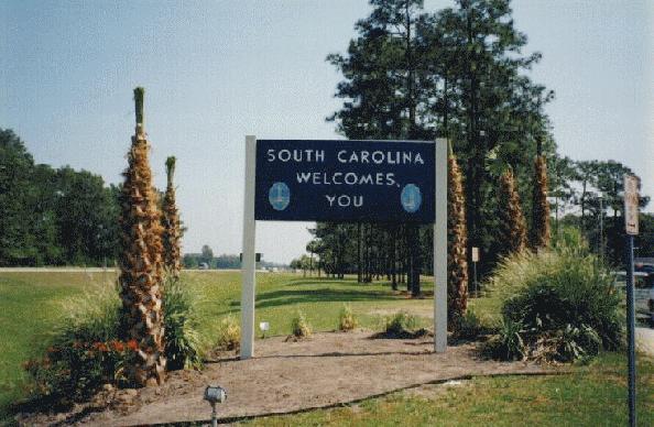
 11:45 AM Entered South Carolina; 136424 Miles; then went to the welcome center.
11:45 AM Entered South Carolina; 136424 Miles; then went to the welcome center.
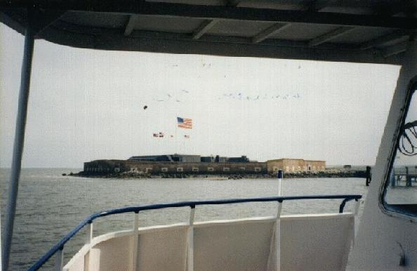
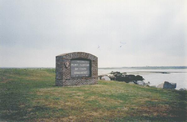
I arrived in Charleston at 2:00 PM, got lost in downtown Charleston, then arrived at "Patriots Point" in Charleston Harbor at 2:25. There were two things to see there, and they would take 11/2 days. Today, I went to Fort Sumter. 
 [10].The tour lasted 2 hours and 15 minutes, of which a total of one hour was on a boat to and from Fort Sumter. I did not like the boat ride because there were seagulls following the boat, which meant a lot of "accidents". I was not hit, but some people were! The fort was... old. It was a funny feeling standing next to the what-used-to-be walls. They had dents in them the size of cannonballs. There were several cannons that were placed in their original 1861 configuration. Inside the fort, there was a steel wall constructed after the Civil War. Outside, there were all the flags flown over the fort in its history. The only interesting thing about Fort Sumter is its history and its role in the Civil War. Otherwise, it is ONLY few brick walls and several cannons on an island in the Atlantic Ocean.
6:30 PM Checked in at Masters Economy Inn in Mount Pleasant, SC, which was walking distance from Charleston Harbor and Patriots Point. Drove to Charleston for dinner at Subway (that was also walking distance).
License Plates:
| GRAYS | NS | Ford F150 Truck (Nova Scotia, Canada plate) |
| $27.75 | Chase | Ramada Inn | Richmond Hill, GA |
| $4 | Cash | Lunch -- Burger King | Charleston, SC |
| $9.50 | CB | Fort Sumter tour ticket | Charleston Harbor, SC |
| $2 | Cash | Postcards & magnets | Charleston Harbor, SC |
| $3 | Cash | Dinner -- Subway | Charleston, SC |

I arrived back at Patriots Point parking lot at noon, then ate the first half of the sandwich as lunch. After that, I went to the "Patriots Point Naval and Maritime Museum".
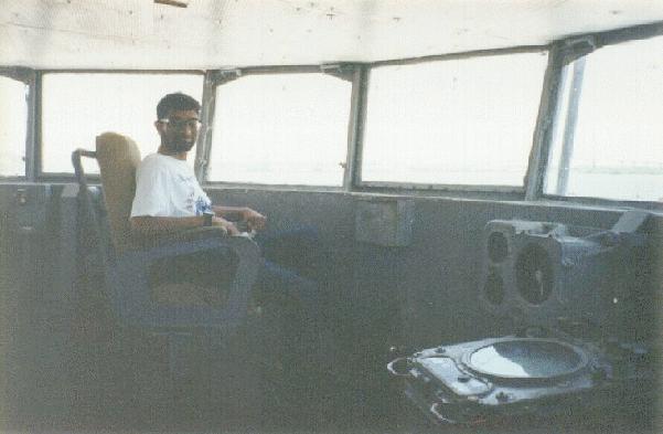
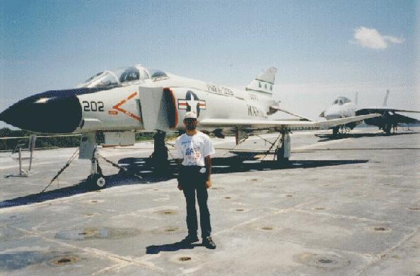 The museum consisted of an aircraft carrier, a destroyer, a submarine, and a Coast Guard cutter.
Ratings:
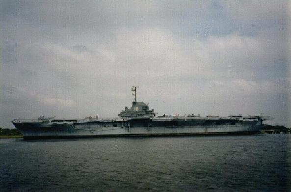 Aircraft Carrier USS Yorktown:
 Destroyer USS Laffey:
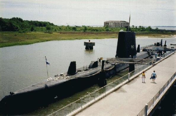 Submarine USS Clagamore:
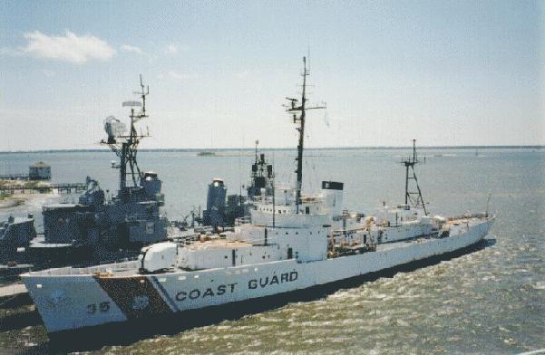 Coast Guard cutter Ingham:
Overall rating for museum:
I had already been on an aircraft carrier on my first trip (USS Lexington in Corpus Christi, Texas), so the USS Yorktown was my second aircraft carrier. But this was the first time I had been on any of the other types of ships. I liked the aircraft carrier best, but that is only because I like planes. The submarine, as the ratings above show, was the worst of the ships. That was because it was very cramped inside. I had to bend down to walk through its hallway. NOT RECOMMENDED FOR THE CLAUSTROPHOBIC! The other ships were fine from that point-of-view. But all these ships, like all military ships, were very dangerous to walk in. There were several instruments, ladders, hoses, pipes, etc. that protruded into the hallways. I don't think there was one single door on any of those ships that was more than three feet tall! In general, getting around inside the ships was quite an experience!
5:00 PM Left Patriots Point and the city of Charleston Harbor.
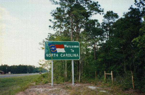 7:20 PM Just a few minutes before one of the most beautiful sunsets I saw on this trip, I entered the state of North Carolina. Immediately after crossing the border, there was a rest area, and I stopped there for the usual "car break" (I had been driving continuously for more than two hours, and although I was not tired, it was time for the car to take a rest).
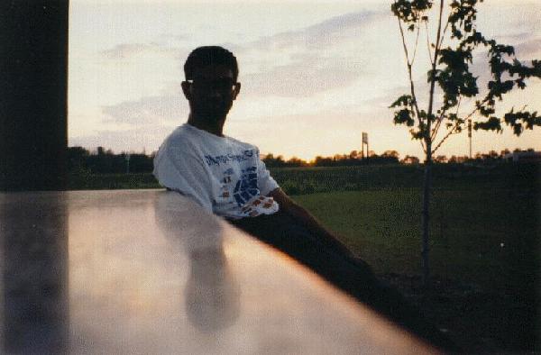 I sat at one of the picnic tables in the rest area, and noticed the beautiful sunset. Took a picture of the sunset alone, then realized that I could place the camera on the table and take a picture of myself in front of the sunset. So I did that. What I did not realize until that film roll was developed was that there was an added bonus to that picture -- the sun's angle at that moment caused my reflection on the surface of the WOODEN picnic table!
Later, I entered the town of Wilmington, NC. It was night-time by then, and the roadside lights were in very poor condition. Several of them were not working, and the ones that were working were very dim. There were also a lot of bumps on the road, and since my car's shock absorbers were not exactly in excellent condition (that's an understatement!), the whole situation reminded me of India. Just a few miles North of Wilmington, I-40 comes to an end. Since I had driven on at least one end each of I-10, I-20, I-30, I-70, I-5, I-25, I-45, I-75 and I-95 AND the Western end of I-40 (in California), I thought it would be nice to also go to the Eastern end of I-40 in North Carolina. "Hey, maybe this will start a trend! I think from now on, I'll make it a point to drive to at least one end of all the major interstate freeways in this country! I've already been on at least one end of so many of them!"
[As of October 2, 1995 (today), I have been to at least one end of the following MAJOR interstate freeways (these are the ones which, by definition, have 1 or 2 digit numbers that end in either `0' or `5', and MOST of which go from one end of this country to another):
Freeways than run North-South:
I-5, I-15, I-25, I-45 (both ends), I-55 (both ends), I-65, I-75, I-85, I-95
Freeways that run East-West:
I-10 (both ends), I-20, I-30 (both ends), I-40 (both ends), I-70 (both ends), I-80 (both ends), I-90
I-5: Mexico Border @ California
I-15: San Diego, CA
I-25: El Paso, TX
I-45: Dallas, TX and Galveston, TX
I-55: Chicago, IL and New Orleans, LA
I-65: Near Gary, IN
I-75: Miami, FL
I-85: Atlanta, GA
I-95: Coral Gables, FL
I-10: Malibu, CA and Jacksonville, FL
I-20: Intersection of I-10 in Texas
I-30: Dallas, TX and Little Rock, AR
I-40: Barstow, CA and Wilmington, NC
I-70: Cove Fort, UT and Baltimore, MD
I-80: San Francisco, CA and Paramus, NJ
I-90: Boston, MA
There is no I-50 or I-60 in this country. There is an I-35 (Texas-Mexico border to Duluth, MN), but I have not driven on either end of that freeway. In addition to the above, I have also driven the ENTIRE LENGTH of I-55 from Chicago to New Orleans (all 926 miles -- no omissions) -- more on that really long detour later in this book. Now back to the story (thank you for your patience)...]
After driving to the Eastern end of I-40, I continued driving North on U.S. Hwy 17 up to Jacksonville (North Carolina, not Florida!), where I ate the second half of the Subway sandwich I had bought in Charleston that morning. I took the sandwich inside a McDonalds restaurant and was eating it there. One of the employees came up to me and said I cannot eat there unless I order something from THAT restaurant! (My sandwich had the packaging from their competitor "Subway", and apparently the McDonalds people did not like it!) That seemed fair enough to me, so I ordered a McDonalds apple pie, finished my Subway sandwich, and then had their restaurant's apple pie for dessert! They still did not like my eating a Subway sandwich there, but I really did not care; and now that I had also ordered something from them, there was nothing they could do about it!
At 11:15 PM, I pulled over in a rest area, wanting to go to sleep. After I parked my car, I noticed there was a factory very close to the rest area. Smoke (or something gray) was coming out of several of its vents. Just a few days ago, I was severely ill. Going to sleep so close to an industrial plant was not wise, and I knew it. But it was 11:15 at night, I was tired, and I had already spent a lot of money on motels. So I went to sleep at that rest area, against my better judgment. The next morning, I would realize my mistake. But not tonight. "I want to sleep NOW, and I don't care how I feel tomorrow."
License Plates:
| WORRIER | ??? | Camaro (Possibly Michigan plate -- went by too fast to recognize) |
Expenses:
| $43.95 | Chase | Masters Economy Inn | Mount Pleasant, SC |
| $2 | Cash | Lunch & Dinner @ Subway | Charleston, SC |
| $9 | CB | Admission -- Patriots Point Naval & Maritime Museum | Charleston Harbor, SC |
| $1 | Cash | Snacks -- Patriots Point Naval & Maritime Museum | Charleston Harbor, SC |
| $10 | Discover | Gas | Mount Pleasant, SC |
| $1 | Cash | McDonalds -- apple pie | Jacksonville, NC |
8:45 AM Feeling better now. Arrived at the waiting line at Cedar Island Ferry. The ferries run all day from dawn to midnight during the summer months. They depart approximately every 30 minutes to an hour, depending on the time of day. The North Carolina AAA map says that "Reservations are recommended" for this ferry. The key word was "recommended"... not "required". So I did not bother to make the reservation. Because of that, I had to wait in line. The people with reservations got on first. I was third in line, and I was told by the dock workers that I would definitely get on the 1:00 PM ferry, but it was "very likely" I would be able to go on one of the earlier boats. So I waited. I had nothing else to do. I could not leave and come back later because I would lose my place in line. There was a gift shop there, so I bought the North Carolina postcard from there and wrote to Perry about what I did last night.
By the time I dropped the card in the mailbox (very conveniently located at the same spot!), the next ferry (supposed to depart at 10:00 AM) was boarding the passengers who had made reservations. Luckily for me, there were a few "no-shows". Three of them was all I needed, and that was exactly how many there were. I was the last car in the 10:00 AM ferry, which departed precisely on time.
Several seagulls came along for the ride. A few just flew down and sat on the ferry, while their friends flew above -- DIRECTLY above the boat. I knew what that meant! I have been bombarded by seagulls a few times back home! I closed the car's sunroof, just in case. I also went inside the snack bar that was on board the ferry. I did not eat anything... this was just my "bomb shelter"! All the other passengers also stayed inside either their cars or this bomb shelter. I looked out the window to see if I could spot any whales or dolphins, but I did not see any.
The ride was two hours long. Two hours of riding up and down... up and down... up.... and...... dooooownnnnnn.... uuuuupppppp....... annnndddd...... dddooooowwwwnnnn..... I started to get seasick. About fifteen minutes into the ride, I went back to the car and went to sleep inside.
At 12:15 PM, the ferry docked at Ocracoke Island and I woke up. As soon as the ferry docked, all of our seagull friends that had hitched a ride at our expense flew away. I was the last one out of the ferry at 12:25 PM.
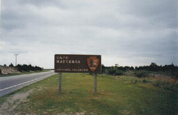
The point of the ferry ride was to do some sightseeing on North Carolina's beautiful Outer Banks, which are a series of islands that form a large semicircle around North Carolina from the Virginia border in the North to Cedar Island in the South. This entire coastline is full of beautiful beaches, several lighthouses, including the tallest one in the country, "Cape Lookout National Seashore" and "Cape Hatteras National Seashore". The Outer Banks is also home to the Wright Brothers Memorial at Kitty Hawk, which was one of my top-priority sightseeing attractions on this trip.
The Outer Banks deserve a recommendation from me -- but there are also some things "wrong" with it. Although ocean views are fairly limited from the main road (Hwy 12), I did see several lighthouses along the way -- but I had to really look for them -- most of them were not immediately visible. Most beaches are not accessible directly from Hwy 12, but there are plenty of signs informing drivers where to turn for the next beach or ocean view. There is a "small town" kind of atmosphere all along the banks. But because of that, some conveniences of large cities are also lacking. I did not see many chain-restaurants. The overnight accommodations[11] are few and far between. Overall, my rating for the Outer Banks and Cape Lookout National Seashore and Cape Hatteras National Seashore is .
1:00 PM Boarded the second ferry in the Outer Banks. This one went from Ocracoke Island to Hatteras Island. This ferry, unlike the first one, was free. No reservations were needed -- this was strictly first-come, first-serve. Because of that, the line was also much longer. Again, I was the last one to get on the ferry. This time, the waters were calm. No seagulls. No snack bar on board. No whales sighted. No dolphins sighted. The ride was also shorter, and I stayed awake the whole time.
 1:40 PM Ferry docked at Hatteras Island, and I was among the first ones out. Time was starting to become a critical factor now...
I found a post office along the road, so I mailed the second batch of photographs home (these were developed in a "Target" in Atlanta).
2:00 PM - 2:40 PM At Hatteras Lighthouse () and beach. This is the tallest lighthouse in the country. I knew about it from the AAA tour book, but the book did not mention if visitors were allowed to go to the top. When I got there, I found out that visitors are allowed to go to the top, but only until 1:00 PM! I felt bad about being so close and still late, but I had something more important to see later that day, and I was not about to waste any more of my time at any of these Fifth-priority places...
3:45 PM - 4:00 PM All along the Outer Banks, I did not find a single fast food chain restaurant. I was hungry at noon after getting off the first ferry... by now I was starving... I finally ate lunch at a McDonalds in the town of Manteo.
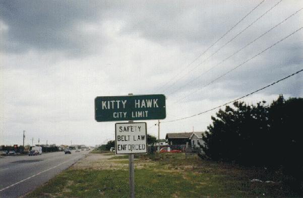 4:30 PM Arrived in the town of Kitty Hawk. Too late. The Wright Brothers Memorial closes at 5:00 PM. The AAA tour book said "Allow 1 hour minimum". MINIMUM. I knew I would take longer. So I did not go there today. Checked in at Holiday Inn Express in Kitty Hawk.
License Plates:
| DEB & BULL | NC | Honda Accord LX |
| $10.11 | Discover | Gas: $11-$0.89 discount if paid by credit card! [10 cents per gallon] | Beaufort, NC |
| $10 | Cash | Fare -- Ferry from Cedar Island to Ocracoke Island | Outer Banks, NC |
| $3 | Cash | Postage -- Hatteras Post Office | Hatteras, NC |
| $3 | Cash | Lunch @ McDonalds | Manteo, NC |
| $9 | Cash | Coke & Sprite @ 7-11 | Kitty Hawk, NC |
8:45 AM After eating a free breakfast, I checked out of the motel and immediately went to the Wright Brothers Memorial in Kitty Hawk.
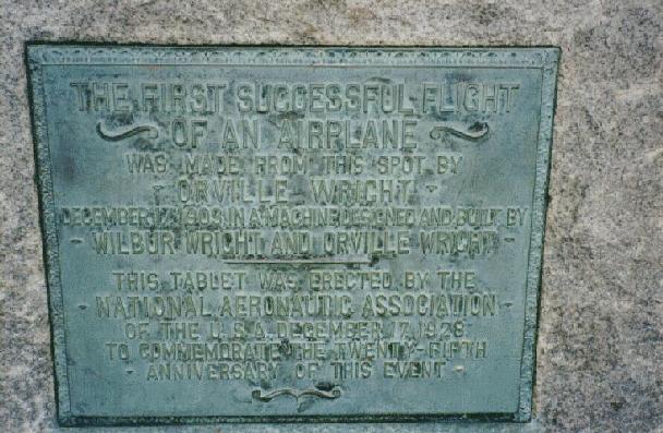
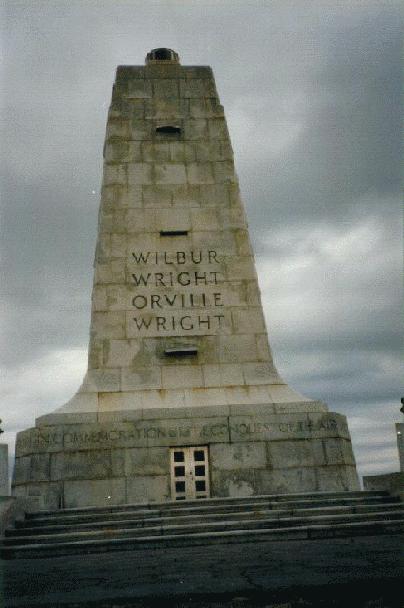 The memorial contained a tall obelisk-shaped monument dedicated to Wilbur and Orville Wright "In Commemoration of the Conquest of the Air". The obelisk was situated on top of a grassy hill, from which the "air was conquered". The ACTUAL spot from where the first successful powered flight took off now contains a plaque which says,
|
THE FIRST SUCCESSFUL FLIGHT OF AN AIRPLANE WAS MADE FROM THIS SPOT BY ORVILLE WRIGHT DECEMBER 17, 1903 IN A MACHINE DESIGNED AND BUILT BY WILBUR WRIGHT AND ORVILLE WRIGHT THIS TABLET WAS ERECTED BY THE NATIONAL AERONAUTIC ASSOCIATION OF THE U.S.A. DECEMBER 17, 1928 TO COMMEMORATE THE TWENTY-FIFTH ANNIVERSARY OF THIS EVENT |
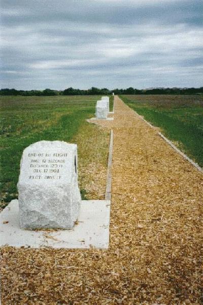
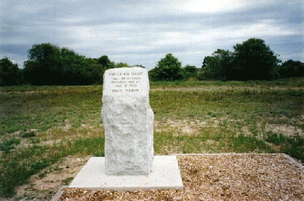
From that plaque, there was a straight walkway extending 852 feet. Along that walkway were four markers. Each marker showed the distance traveled and the flight times of the first four flights that winter day in 1903. The Wright Brothers flew four times on that day, alternating pilots for each flight. Each flight was longer than the one before. The fourth and final flight, piloted by Wilbur, crashed 59 seconds after taking off. That final flight traveled a distance of 852 feet[12]. The four markers were in a straight line, so they accurately showed the comparative distances of the four flights.
The Wright Brothers' bicycle shop was also a part of the memorial. The wooden shack had been transferred here piece-by-piece from Dayton, Ohio.
In a museum at the entrance, a replica of the Wright Flyer was on display, along with portraits of all pioneers of flight, including portraits of Otto Lillienthal[13] and Samuel Langley[14].
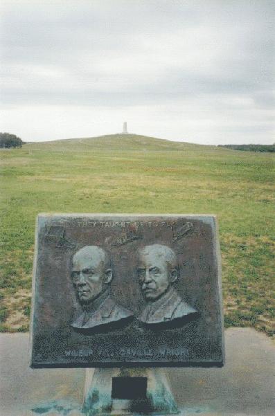 My rating for Wright Brothers Memorial = .
I left the memorial at 11:30 AM (I was there for two hours and fifteen minutes). I withdrew some cash from a bank in Kitty Hawk, took a picture of a sign "Kitty Hawk City Limit", then started driving North toward Virginia. "Washington DC, HERE I COME!"
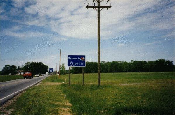 12:40 PM Virginia (and city of Norfolk); 137022 miles
Ate lunch at both Burger King and McDonalds, then continued driving North.
2:00 PM - 3:00 PM Chesapeake Bay Bridge-Tunnel ( -- not more because there was a $10 toll; if it were not for the high toll, I probably would have given a higher rating). This was the first time that I had been in an under-water tunnel. It is an interesting bridge-tunnel combination, with a pullout/rest area to enjoy the view of ships going OVER the road! That was quite fascinating!
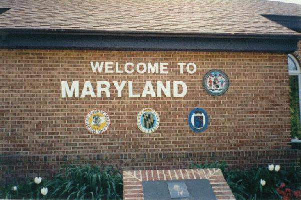 4:20 PM Maryland; 137136 miles.
4:20 PM - 5:00 PM At Maryland visitor center: made reservation for Days Inn at Annapolis, which was only a 1/2 hour drive from Washington. "Tonight, I shall be in our nation's capital!!!"
7:00 PM Chesapeake Bay Bridge = (because there was no toll on this bridge). Half an hour later, I was in my room at the Days Inn in Annapolis, MD.
8:30 PM I had driven almost 7000 miles to Annapolis. The BIGGEST attraction on this trip was Washington, DC. I wanted to go there, and I wanted to go there IMMEDIATELY! So what if it had started to rain?
 On the fourth day of the fifth month of this year, which was the twenty-seventh day of my second trip, twenty-one hours into the day, I, Ishaan Gokhale, entered the District of Columbia.
It was still raining.
I was driving Westbound on East Capitol Street. The very first thing I saw was the Robert F. Kennedy stadium, which I did not recognize at that time.
The first thing I RECOGNIZED was the colossal dome of the United States Capitol Building. "WOW!" It was lit with floodlights. Just over the dome, I saw an obelisk. It was George's obelisk, and I recognized that too. That was also lit with floodlights. That combination of the Capitol and the Washington Monument at night looked SPECTACULAR! "God, I am ready to die now! You can take me anytime!"
I had three maps with me and I knew I was supposed to turn right on 1st Street, toward the Senate Office Buildings. I did turn right on 1st, then an immediate left on Constitution Avenue, which, according to the maps, would take me right next to all the Smithsonian Museums on the Northern end of the Mall. I knew that much from the maps. But I had not counted on the fact that this was a large city, it was a downtown area, and it was raining. I was not familiar with
the city and it's "driving style". I had remembered reading in one of my tour books (not AAA) that most people in this country are just as familiar with Washington DC as they are with their own home town. It is the most popular attraction on everyone's "list of things to see in USA". I had not even considered the fact that there are tourists everywhere! At night. In the rain. They were still there. They interfered with MY driving. I had carefully studied the maps before leaving the motel, so I would know EXACTLY when and where to turn. With all my planning, with all my maps, I still got lost somewhere in NE Washington. I remember thinking to myself that if I could see the Washington Monument, I was all right. All I had to do was just drive toward the Monument, and EVENTUALLY, I would get back on Constitution Avenue.
That worked. I was back on Constitution, heading West towards the Lincoln Memorial. I saw many Smithsonian museums along the road, but I did not recognize any of them. Later that night, when I was back at the motel, I looked at the map and found out I had driven by the National Gallery of Art, National Archives, National Museum of Natural History and National Museum of American History.
I knew I wanted to make a slight detour going North on 15th Street, West on Pennsylvania Avenue, then South on 17th Street. This detour was to drive by the White House. I had no problems with that. I saw the White House, got back on Constitution Avenue, and started driving West again toward the Lincoln Memorial. Somehow (and don't ask -- I don't remember this part), I ended up driving by the Kennedy Center for the Performing Arts, which is in the opposite direction of where I wanted to go! I do not know how, but somehow I got back to 23rd Street, which goes South to the Lincoln Memorial.
At the Lincoln Memorial, I wanted to drive by the FRONT side. I did not know that the front side is closed to all motor traffic. The roads were so confusing to a first-timer such as myself that somehow, I drove around the back side, entered the Arlington Memorial Bridge, went into Arlington, VA; and before I knew where I was, I entered the Capital Beltway (I-495), made a full circle of the city going in the OPPOSITE direction, and ended up on Highway 50 East and back to Annapolis, MD!
I had entered Washington, DC at 9:00 PM, and by the time I got back to the motel it was 11:00. It was raining the whole time.
After I got back to the motel, I checked the Washington DC map again and found out I had actually seen a lot more than what is mentioned above. I had also seen in those two hours the Supreme Court, Library of Congress, Executive Office Building, Constitution Gardens, the back side of the Vietnam Memorial, and the back side of the Lincoln Memorial. Of all the places I saw that night, the only places I recognized on my drive were the Capitol, Washington Monument, White House, Kennedy Center and Lincoln Memorial.
License Plates:
| 3 CABLES | VA | Jeep Grand Cherokee |
| SEA & SKY | NC | Toyota MR2 (a land vehicle -- nothing to do with the sea or the sky) |
| I AM PT | VA | Honda Accord ("and I AM IG") |
| BEACH B'S | NC | Toyota Celica |
| L8DEBUG | VA | Volkswagen Bug |
| FERN REP | VA | Mercury Minivan |
| IJAWJA | VA | Mercedes Benz 190E |
| DO LUNCH | VA | BMW 325 ("O.K., but since you're driving the BMW... so you pay") |
| RD WITCH | VA | Honda Civic |
| THFUZZ | VA | Toyota Supra |
| SKYS 2C | VA | Oldsmobile ("Me too...") |
| MY WIFS | VA | Lexus ES300 ("good car... too bad it's not yours!") |
| ITALY 7 | VA | Honda Accord (Japanese car, not Italian) |
| JAZ SNDI | MD | Oldsmobile |
| $44.55 | Chase | Holiday Inn Express | Kitty Hawk, NC |
| $80 | Discover | Cash withdrawal | Kitty Hawk, NC |
| $3 | Cash | Lunch -- Burger King | Norfolk, VA |
| $2 | Cash | Lunch -- McDonalds | Norfolk, VA |
| $10 | Cash | Toll -- Chesapeake Bay Bridge-Tunnel | Virginia/Maryland |
| $12 | Discover | Gas | Salisbury, MD |
[10]
= Better than but not as good as .
[11] I refuse to call those things "hotels".
[12] The first flight, piloted by Orville, landed safely twelve seconds after take-off and traveled a distance of 120 feet.
[13] His wind-tunnel experiments were proven wrong by the Wright Brothers.
[14] He was competing against the Wrights to build the first self-powered plane. He lost by just a few months.