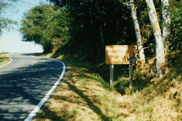
 Instead, after checking out rather earlier than normal, I drove to Redwood National Park.
I had originally wanted to see the "Trees of Mystery" park in Klamath. When I woke up this morning, I decided not to go there -- I had already seen it before anyway. Instead, after checking out rather earlier than normal, I drove to Redwood National Park.
At the park's visitor center, I bought a souvenir National Park Passport, stamps for that passport, and a 1996 National Park calendar. The calendar was for Mom. Everything else was for me. The National Park Passport is a small book that works very much like a real passport. Every National Park in the country has a "Stamp Station". The idea is to record the date you visited that particular park in the National Park Passport. I made the mistake of buying this Passport at the end of my trip, rather than in the beginning. But I still considered this to be a valuable souvenir of my trip as a whole, although it did not have any stamps in it!
I left the visitor center and started sightseeing at the park. I had also been here before with my family, and remembered that I had not enjoyed it very much then. So I was not expecting to see anything extraordinary. The only reason I came here was because it was on my route, so I decided to stop by for a quick look. Rating for Redwood National Park = 
 .
.
Almost immediately after exiting the park, I saw something that is "typical California": I was driving along the coast, and there was a very thick fog. As I was driving, I took a photograph of the fog, then wrote in my notebook, "Fog along the coast -- [in red ink:] Yep, back in California again!!!" When that film roll would be developed, I would label the back side of that photograph, "The morning coastal fog that is so common in California!" I was home. (Home state, anyway!)
The place where I took the photograph also had a sign that showed that San Francisco was 283 miles South of that point. Since the entire route was a scenic road, I decided to drive down to San Francisco and spend the night there -- then drive back home the next day, which would be the final day of my trip.
I stopped in the town that gave California its state motto (or maybe it was the other way round!): I arrived at the town of Eureka just a little before noon. After filling up on gas, I went to the AAA office there to get a state map of California (a better one than the one I had) and city maps of San Francisco, Stockton and Fresno. I already had a map of San Francisco, but by this time, I had learned it is always better to have two (or more) maps of a large city. As for the Stockton and Fresno maps, I finally, FINALLY, got them! Throughout this trip, I had gone to several different AAA offices all across the country (including the ones in the Los Angeles area), but NONE of them had maps of Stockton or Fresno! It was miraculous -- the AAA offices in the BIG CITIES like Los Angeles or New York City did not have maps of Stockton or Fresno, but the AAA office in Eureka had them! On this day, the day that turned out to be three days away from the end of the trip, I finally had all the maps I had
wanted on Day #1!!!
Fully confident that I would not get lost anywhere else from now on, I left Eureka and drove further South on Highway 101.
After getting lost somewhere South of Eureka trying to look for a restaurant, I stopped at a Dennys restaurant in the town of Fortuna. I went inside and ordered my lunch "to-go". I waited in the restaurant for twenty minutes, while my lunch was being prepared. When it was ready, I picked it up and went to the car. I ate the lunch in the car, which was still parked outside the restaurant. The reason I did all this was because I was too cheap to tip my waiter/waitress, yet I did not mind paying $10 at a Dennys instead of $2 at a Taco Bell! I still cannot figure that one out, to this day!
While I was eating my lunch, I was looking at my new California map, and immediately decided that if I wanted to get home at a reasonable time the next day, I had to drive further than San Francisco tonight. Although it is only a day's drive from San Francisco to Los Angeles, I had also wanted to do some sightseeing at two places that I knew were excellent -- Yosemite National Park and Sequoia National Park. Starting from San Francisco, going to Yosemite and Sequoia and THEN driving down to Mission Viejo would take too long. I decided to drive down to Stockton tonight. That would save me a valuable hour tomorrow. I considered not going to San Francisco at all, but quickly dismissed that idea -- San Francisco was symbolic as "The Last Major City" on this trip.
After deciding on my route, I left the Dennys and continued driving South.
On a previous trip up here with my family, I had seen both Redwood National Park and Humboldt Redwoods State Park. I had enjoyed Humboldt Redwoods State Park a lot more than the National Park, so I wanted to go there too.
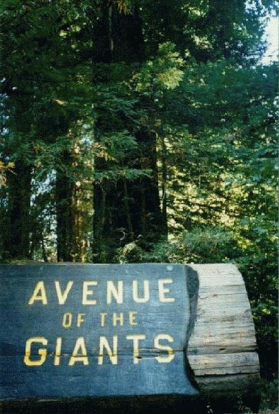 1:42 PM Took the exit for Humboldt Redwoods State Park at the town of Pepperwood. Although I was technically outside the park boundary, there were several redwood trees along both sides of the road. Soon, I came across a sign that said,
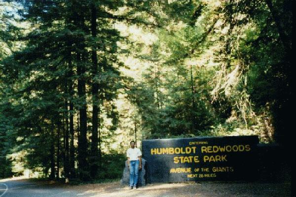 ENTERING
HUMBOLDT REDWOODS
STATE PARK
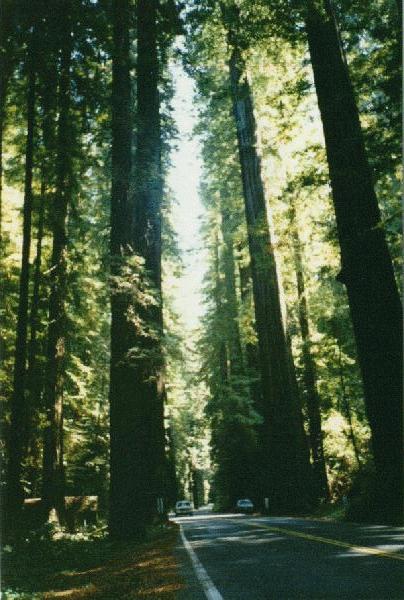
AVENUE OF THE GIANTS
NEXT 26 MILES.
I photographed that sign and another "Welcome" sign nearby that read,
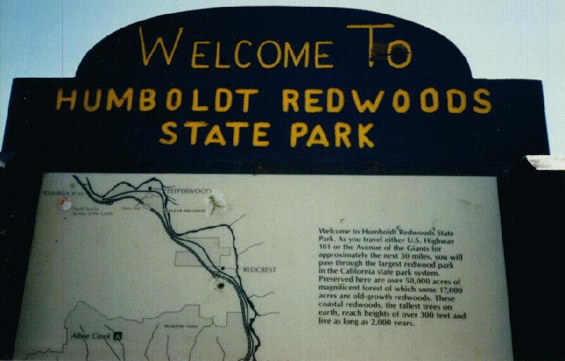 "Welcome to Humboldt Redwoods State Park. As you travel either U.S. Highway 101 or the Avenue of the Giants for approximately the next 30 miles, you will pass through the largest redwood park in the California state park system. Preserved here are over 50,000 acres of magnificent forest of which some 17,000 acres are old-growth redwoods. These coastal redwoods, the tallest trees on earth, reach heights of over 300 feet and live as long as 2,000 years."
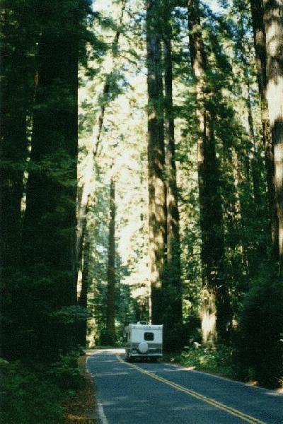
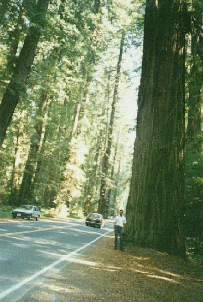
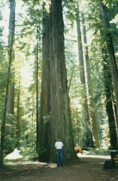
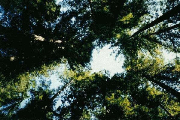
For the first time after leaving Mount Saint Helens, I was amazed at the statistics of what I was seeing. "The tallest trees on earth... heights of over 300 feet". Although I was looking at the trees, I still could not comprehend the fact that these are not only the tallest, but also some of the oldest trees on earth. I remember the next thing I thought about was what Sachin might say if he came here -- "they are JUST trees -- we've seen millions of them! Can we go now?" I tried to understand that point-of-view as well, but was too impressed with what I saw regardless what anyone else might think. My rating for Humboldt Redwoods State Park was .
3:40 PM Ended the 26-mile drive on Avenue of the Giants and entered Highway 101. From here, it was 205 miles to San Francisco. I expected to be there by 8:00 PM, then Stockton by 9:00 PM. As it turned out, I was only half-right!
I came across a slight unexpected problem in the town of Leggett. I saw an orange construction sign that said "ROAD CLOSED DUE TO LANDSLIDE AHEAD -- WATCH FOR DETOUR SIGNS". Well, why not? On this trip, I had been through blizzards, hail, tornadoes, why not a non-weather related problem? I looked at other drivers and they all appeared to be irritated that this landslide ahead would delay them. Frankly, although timing was important to me for today, I really did not care about any delay. I had a smile on my face!
The detour was 8 miles long and took 10 minutes, which was not bad at all!
At Leggett, the road branches into Highway 101 to the East and Highway 1 to the West. Both those roads eventually get to San Francisco, with Highway 101 being the faster route and Highway 1 being the slower but more scenic coastal route. Until now, I had not decided which road to take to San Francisco. By coincidence, I happened to be in one of the lanes that went to Highway 101, and I happened to just stay in that lane, and I ended up going South on Highway 101. It did not really matter. I had been on both those roads before!
As I was nearing San Francisco, night was starting to fall. Before, I had been worried that the Golden Gate Bridge would be fogged in, as it usually is. At nightfall, I did not need to worry about that anymore! Fog did not matter because the lights on the bridge would make the bridge visible. Still, I was hoping there would be no fog.
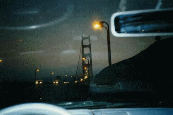 My prayers were answered. At 7:58 PM, I saw the Golden Gate Bridge, and it was not fogged in. Two minutes later, I entered the bridge and the city of San Francisco, the second-most beautiful city in this country. I paid the toll, and for the first time on this trip, I did not mind paying a toll -- after all, this was the second-most beautiful city in the country!
I had been to (and driven in) San Francisco several times before, so I was very familiar with the roads. Before headin' off to Stockton, I also wanted to go on the crookedest street in the world. Coming from the Golden Gate Bridge, Highway 101 turns into Lombard Street, which eventually goes through a series of sharp turns making it the "crookedest street in the world". As I was driving on Lombard Street, I saw several signs that said "Crookedest Street closed due to construction". Oh, well! I had been there several times before, so I did not feel too bad about it! I entered the San Francisco-Oakland Bay Bridge and crossed the San Francisco Bay into Oakland. From there, I was supposed to go Southeast towards Stockton. I was in the right lane. The car in front of me was driving extremely slow, and I wanted to pass it. When I did that, I missed my exit and accidentally went North towards Berkeley! By the time I was headed the right way again, it was 9:00 PM.
An hour later, I checked in at an Econolodge in Stockton (Indian-owned).
License Plates:
| THANX EE | CA | Acura |
| 50 CONV | CA | Mercury Convertible (old -- could have been 1950 model) |
| BOKS4RP | CA | Honda -- a "box car" |
| MNCNTRL | CA | Nissan |
| $43.20 | Chase | Motel Trees -- paid at check-in | Klamath, CA |
| $19.14 | CB | Souvenirs: -- Redwood National Park 1996 National Park calendar National Park Passport Individual stamps for a few National Parks to stick in Passport | Redwood NP, CA |
| $8 | CB | Gas -- Shell | Eureka, CA |
| $10 | Cash | Dinner to-go -- Dennys | Fortuna, CA |
| $6 | Cash | Two quarts engine oil and California postcard | Weott, CA |
| $6 | Cash | Gas -- Chevron | Cloverdale, CA |
| $3 | Cash | Toll -- Golden Gate Bridge | San Francisco, CA |
Go to start of this date
Go to start of this section

Today was the last full day of sightseeing on this trip. I had fixed with Parixit that instead of going directly to Mission Viejo tonight, I would be coming to his apartment in Moorpark -- I had never been to his apartment before, and saw this as a perfect time to stop by. I had memorized his address, so it would not be too difficult finding his apartment!!! Or so I thought.
Everything I wrote in my notebook for this day (and the next day) was written in red ink -- I titled this day "THE LAST DAY #1 -- DAY #140". Another change in my notes was that I wrote the EXACT times everything happened, rather than rounding off the times to the nearest 5-minute interval, as I had been doing in the past.
This day was a lot more than just the "Last Day #1", as I soon found out. This day also set a new trip record -- a record that I had no intention of breaking. I was trapped in the most severe traffic jam on this entire trip. More on that later...
Before leaving Stockton, I ate lunch at a Burger King. I filled up on gas at the nearby town of Manteca. I left Manteca at 11:13 AM.
I was driving on Highway 120, which goes to Yosemite National Park.
11:52 AM All traffic on that road came to a full stop. Just out of habit, I noted the mileage at this point -- it was 1,998 miles.
The traffic did not move for a long time, and eventually, I turned off the car engine.
A little while later, I turned on the engine, moved about 10 feet, stopped, then turned off the engine.
Since I had nowhere to go and nothing else to do, I started catching up on my OTHER notebook. I had two notebooks -- I would write everything in a small, compact notebook (sometimes while driving), then copy everything neatly in a larger, thicker notebook. Lately, I had been falling behind in copying to the larger notebook. For the next half hour, while I was stopped in this traffic jam, I was copying my notes from the small notebook to the large notebook.
I saw an ambulance and police car go by on the shoulder, and realized there must have been a very serious accident ahead to create all this -- it was the only explanation.
Eventually, I did start moving again, but only very, very slowly.
An exact copy of my notes, except for the additions of "PM" and whatever is in italics:
12:23 PM 2000 miles in this car. Still trapped in traffic.
12:25 PM Out, 2000.4 miles (Yup -- big accident)
1:07 PM Town of Big Oak Flat -- stopped to cool engine (climbing up to here)
$7 (Cash) -- Coke-n-cookies-n-stuff @ BP gas station in Big Oak Flat.
1:51 PM Left Big Oak Flat.
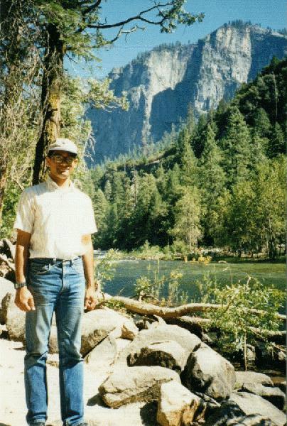
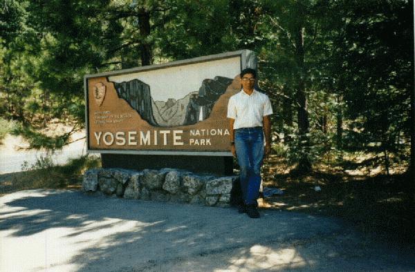 2:23 PM Yosemite NP; 2060 miles.
$13 (Cash) -- more passport stamps
2:43 PM Started driving thru NP
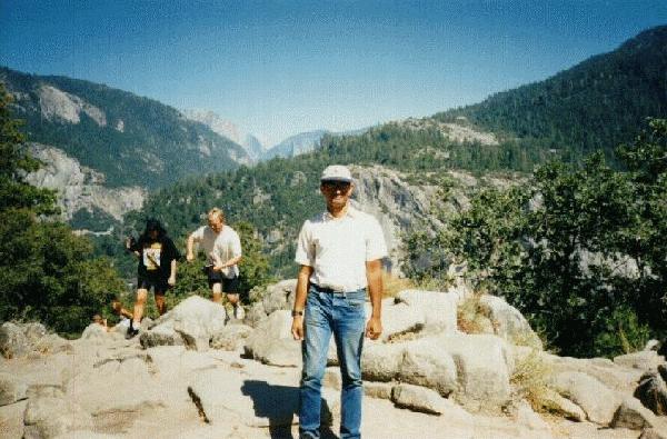
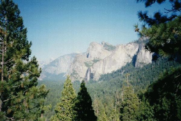 3:07 PM First view of El Capitan & first stop @ a viewpoint in this NP; 2075 miles
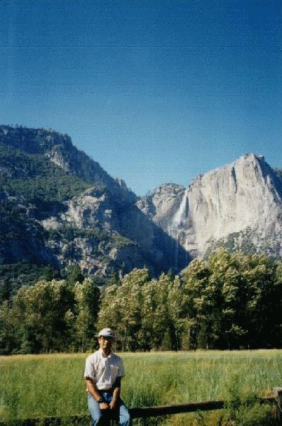
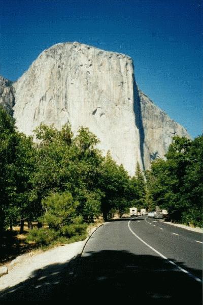 This information was wrong. I had confused "El Capitan" with "Half Dome". I did not see El Capitan here -- I saw Half Dome. Later, I saw El Capitan and other attractions in Yosemite, including Yosemite Falls, the tallest waterfalls in the country. When I entered the park, I had already decided to give it a rating -- based on my two previous visits. Because of that, this attraction became the only attraction on this trip that received its rating BEFORE I saw it (on this trip). It was also the last attraction on this trip -- seen on the last full sightseeing day on this trip.
5:14 PM Left NP;
It was too late to go to Sequoia National Park, so that was canceled without any regrets.
6:31 PM In-n-Out Burger, Fresno -- $4 cash. Ate possibly my "LAST SUPPER". Called B.J.'s[66] and P.G.[67]
I consider "In-N-Out Burger" to be the single best fast food restaurant chain in the country, both in the quality of their food and their price. So it was a fitting place to eat what would be my "Last Supper". Unfortunately, In-N-Out is a localized chain and their restaurants are found only in California and Nevada. This was my only meal on this trip at an In-N-Out Burger, which made it even more special as my "Last Supper".
7:09 PM Left In-N-Out.
7:52 PM This would be my last stop before entering the Los Angeles metropolitan area: B.P. gas station @ Tulare -- fillup -- $7 (cash).
7:56 PM Left Tulare.
9:31 PM LA County; 2336 miles.
I had always imagined coming back home after this trip to be a special event. But since I had come back home in the middle of the trip, I was not so excited this time. Also, I really did not want the trip to end, and entering Los Angeles County meant the trip had almost ended...
10:16 PM Entered I-405; 2386 miles.
I-405 was yet another reminder that I was back home...
10:18 PM Entered Highway 118; 2387 miles.
10:49 PM Parked in front of Parixit's apartment complex; 2413 miles.
Back to normal format:
Parixit's street address was "51 Majestic Court #905". That meant Building #51; Apartment #905. After all those postcards I had written him, I had memorized that address, and felt I would not have any problems finding his place! After parking the car, I walked inside the apartment complex, looking for Building #51. There was one slight problem -- None of the buildings had clearly visible building numbers painted on them! Fortunately, I saw some of the residents relaxing and chatting in front of their apartment. I asked one of them where Building #51 is. She replied I was standing in front of Building 51 -- Building 51 was THIS building. I thanked her and left, looking for Apartment #905 in that building. When I did not find it, I came back and asked her where Apartment #905 is! She told me it was "in that building over there". Now I was confused. She had just told me that Building #51 was the building her apartment was in. Now she was telling me that Apartment #905 in Building #51 was in another building! A little irritated, I asked her to clarify herself. She told me that ALL the buildings were Building #51, and that Apartment #905 was in "that building over there".
Sheesh!
I finally found Apartment #905 and "checked in".
License Plates:
| WOLVIES | CA | Volvo |
| TOOTS F | CA | Ford Mustang |
| 3D WIZ | CA | Honda Civic |
| KOWSHOW | CA | Chevrolet |
| $33.26 | Chase | Econolodge -- paid last night at check-in | Stockton, CA |
| $3 | Cash | Lunch -- Burger King | Stockton, CA |
| $6 | Cash | Gas -- ARCO | Manteca, CA |
| $7 | Cash | Coke-n-cookies-n-stuff -- B.P. gas station | Big Oak Flat, CA |
| $13 | Cash | National Park Passport stamps | Yosemite NP, CA |
| $4 | Cash | The Last Supper -- In-N-Out Burger | Fresno, CA |
| $7 | Cash | Gas -- B.P. gas station | Tulare, CA |
Go to start of this date
Go to start of this section
THE REAL LAST DAY. DAY NUMBER 141.
I had been on the road for almost five months. Today, this trip would be over.
My notes:
8:14 AM Woke up for the last time.
8:28 AM Got out of bed for the last time.
8:31 AM Listening to L.A. radio stations for the first time.
12:01 PM STARTED CAR!!! 2414 MILES
12:04 PM DRIVING
WEESIE (CA Chrysler New Yorker)
$6 (Cash) -- 2nd-last gas fillup @ AM-PM @ Moorpark.
This actually turned out to be the LAST gas fillup.
Went to PG's office; a hole lotta cars parked there! (Even on Saturday)
12:21 PM Left office: NEXT STOP:
1:01 PM First sight of L.A. skyline.
NUZZLND (CA Chevrolet Blazer)
I wrote that while driving. When I did, Parixit looked at me and shook his head. All I could say was "Dad told you, didn't he?" (referring to my writing in my notebook while driving). All he could do was smile. That was enough -- I knew. When I saw the next personalized license plate, I reached down to pick up my notebook. Parixit quickly snatched it from my hand and wrote in my notebook:
LITLEYS (CA Jeep Cherokee)
He kept the notebook with him, so I would not be able to write in it again. We saw one more license plate, and he wrote that one in the notebook...
APLEES 1 (CA Merc 300)
When we were on Hidalgo Street in Mission Viejo -- less than one mile from home -- a car turned in front of us and I saw it had a personalized license plate. Immediately after I noticed that plate, we passed another car that was parked on the side of the road -- that parked car also had a personalized license plate. Suddenly, I pulled over and stopped the car. I grabbed the notebook from Parixit and wrote:
TOGOS MV (CA GMV)
The "GMV" was actually a "GMC" -- I wrote it wrong. As I was writing them down, Parixit told me, "GOOD -- THAT'S THE WAY TO DO IT!!!". I had no response to that.
2:12:31 PM HOME. 2,516 MILES. Parked;
2:12:50 PM TURNED OFF ENGINE;
26,951 Total Miles on Toyota Tercel and Ford Escort
After going to forty-eight states in one hundred forty-one days, driving twenty-nine thousand four hundred and sixty-seven miles in three cars, spending eight thousand four hundred and fifty-eight dollars and thirty-six cents (and thereby going in debt by more than four thousand dollars), enduring the death of a good friend, almost dying myself several times, seeing practically everything that was worth seeing in all forty-eight continental states, getting lost practically everywhere I went, getting one traffic ticket and two warnings, seeing five hundred twenty-six license plates and ninety-nine miscellaneous items, mailing one hundred and twenty-six postcards to three people in three different addresses and having a helluva time doing all that, this second trip came to an end. I was starting to miss it already...
On April 8, 1995, I had a car; I had more than $ 5,200 in my back account; I did not owe any credit card company any money; and I was looking forward to an adventure of a lifetime.
On August 26, 1995, the adventure of a lifetime was over; I had no car; I had less than one thousand dollars in my back account; I owed three credit card companies a total of four thousand dollars; and I would be going back to work next Tuesday.
If I had to do it all over again, I wouldn't change a thing.
License Plates:
Go to start of this date
MISSION VIEJO,
CALIFORNIA
!!!!!!!!!
(hopefully!)
YDSH MOM (CA Mitsubishi van)
+ 2,516 Miles on Mazda 323 =
---------
29,467 TOTAL MILES driven on the entire trip from start to finish!!!
WEESIE
CA
Chrysler New Yorker
NUZZLND
CA
Chevrolet Blazer
LITLEYS
CA
Jeep Cherokee
APLEES 1
CA
Mercedes 300
TOGOS MV
CA
GMC
YDSH MOM
CA
Mitsubishi van -- The last license plate seen on this trip -- seen when I was less than one mile from home.
Expenses:
$6
Cash
Gas -- AM/PM
Moorpark, CA
Go to start of this section
Continue on to End Notes and summary tables
Go to Table of Contents